
How Do Remote Pasture Measuring Tools Work Exactly?
Practical pasture decisions for farms that need clear, reliable information.
There’s been much discussion in recent years on remote pasture measuring and automatic pasture management tools.
But, what is remote pasture measuring and what are remote pasture measuring tools. How do they work exactly?
I’m here to tell you all about it.
Why?

So you can make the best-informed decision if this method is good for you and what remote pasture measuring tool to choose from in that case. There are many online platforms that offer remote pasture measurements.
Remote pasture measuring is basically measuring your pasture from space.
Can that be done, you might think – at an accurate level?
Yes – depending on the quality of satellite imagery, and quality of other factors that remote pasture measurement tools use.
Also, some online platform tools go about it in different ways – and I’m here to tell you how.
Let’s start with how remote pasture measuring works exactly!
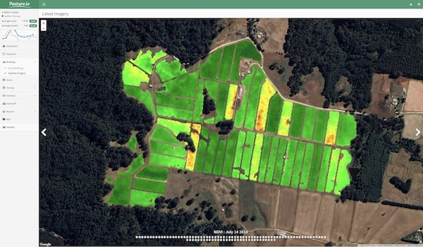
NDVI – Remote Sensing from Space
All remote pasture measurement tools use NDVI – Normalised Difference Vegetation Index.
They use this on top of other methods and tools as well.
What is this NDVI, then?
It’s a method to calculate the height, density and health of vegetation.
NDVI wasn’t originally thought out to calculate pasture – but it is used for it as well.
Why does this matter, though? Who cares if it measures tree leaves or your feed wedge?
It matters because when it comes to pasture – NDVI has one big limitation. It can’t go past measuring 2500 KgDM/ha. That’s about the amount of biomass when your pasture’s canopy closes. NDVI gets stuck here – it’s no longer able to tell you if you have 2750 KgDM, 3000 or 4000 KgDM/ha. Your NDVI index can never go past +1 – and that’s about 2500 KgDM/ha.
When you’re planning which paddock to graze your cattle on – you want to know if you’re going in on a paddock with 1000, 1500 or 2000 KgDM/ha of available feed on offer.
Also, when you are planning which paddocks to harvest for forage - you also want to know the amount of pasture biomass you have. To better plan for wintertime or drought by knowing what stock of feed you can have.
NDVI just isn’t enough to make fully informed grazing management decisions that benefit your dairy farm.
But how does NDVI work?
By knowing how NDVI works – you can tell why it’s so limited.
NDVI remote sensing (from space and satellites) uses visible and near-infrared light.
Now, healthy and dense pasture reflects green and unhealthy sparse pasture reflects red. Quite simple and basic. A low height feed wedge will show up on the red spectrum from red, orange to yellow – while a high feed wedge will show up on the green spectrum – from light green to dark green.
But once the canopy closes – no more green can be measured. It will just appear as dark green no matter the quantity of pasture biomass you have above 2500KgDM/ha.
High-resolution satellite images
To compensate for the limits on NDVI, well-performing remote pasture measuring also needs to involve satellite imagery.
Some online platforms use satellite imagery of lower resolution while others use higher resolution maps. You can tell the quality of their satellite imagery from their paid plans’ monthly fees.
As you might imagine, the highest resolution satellite imagery is not cheap – which means paid plans will have to be more expensive. Pasture measurement tools that offer cheap monthly plans just can’t afford to offer high-quality satellite maps – and they don’t.
Two free satellite imagery providers are MODIS and Landsat 8. They are free for a reason – the satellites in these two systems provide lower quality resolution and a lower revisitation frequency.
Let’s have a look at the characteristics of both these systems:
MODIS:
- Free to use
- Resolution: 250m2, 500m2, and 1000m2
- Revisitation Frequency: up to 1 to 2 days
Landsat 8:
- Free to use
- Resolution: 30m2
- Revisitation Frequency: Every 16 days
However, there are other more efficient and higher-quality satellite systems. Systems that provide higher resolution satellite images for better quality decisions.
At Pasture.io we use the PlanetScope Constellation system – and we pay for it.
For the record, we also tap into other satellite constellations, but that is for another article.
What do we get in return for paying for the imagery?
The ability to offer our users stellar resolution close to 3m2 for their pasture management for cattle. This means, that our paid plans have higher costs – but offer the highest quality that yields accurate pasture measurements.
It’s what you are or would actually be paying for resolution imagery in return!
PlanetScope Constellation:
- Pay to use
- Resolution: 5m2, 3m2, and 75cm2
- Revisitation Frequency: up to daily
The PlanetScope Constellation is very different from the free MODIS and Landsat systems! With such a high res satellite map, we can easily compensate for the shortfalls of NDVI.
We’re not sure about other remote pasture measuring tools who offer lower quality space images. Make sure to check what satellite system a remote pasture measuring platform uses before making your decision!
You might be happy to be spending just $60 a month thinking you’re getting accurate measurements – but you won’t and it will be money thrown out the window.
If it sounds too good to be true – it is.
Weather data
Remote pasture measuring is also about receiving accurate growth rates on your grass. Growth rates take into account your pasture’s growth history as well as other factors. One of those factors is the weather.
You probably were aware that weather conditions affect your pasture’s yield and quality. You know, if it’s warm and plenty of moisture, your grass is going to be firing compared to if it’s cold and no moisture.
In that case, weather data is more than important. You shouldn’t expect the same growth rate across seasons or in different weather conditions such as extended periods of rain or drought. Rainfall, as you can imagine, affects annual pasture predictions.
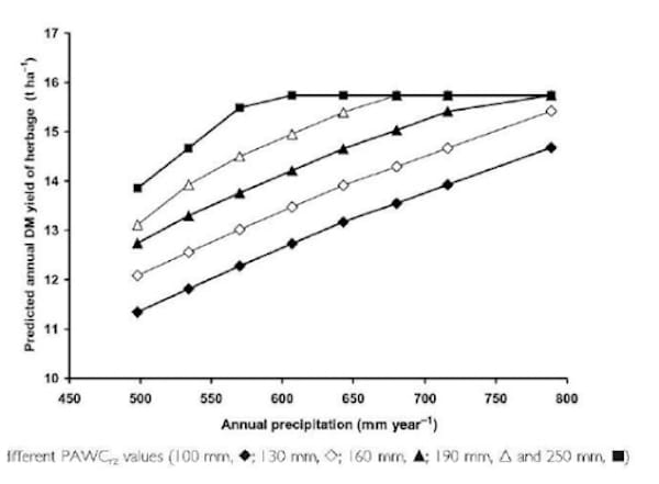
(Source: Current methods to estimate grassland production and biological fixation)
This information is important to avoid overgrazing, to know what to do about feed supplements and know when you have extra pasture in your paddocks.
Remote pasture measuring tools get in contact with weather forecast organizations and connect their platform to weather data.
This weather data is connected to the platform and a smart or not so smart machine learning environment (or AI). The smarter the AI the better the remote pasture measuring tool calculates and forecasts your growth rate.
Farm Records / Paddock Activities
Farm records need to be a part of remote pasture measuring and a part of pasture management and grazing tools.
Why are farm records relevant?
They add information to the machine learning platform to help estimate biomass and calculate grass growth.
What type of information is relevant?
As you might be aware, fertilising affect the quality and density of your pasture.
Fertilisers that get into the soil can help your pasture or damage your pasture. Read more about soil sampling and soil testing – it’s recommended you do a soil test on a dairy farm every two or three years to better decide on fertilising and nutrient regimes.
Other information that is relevant for good grazing management, is your spraying, planting and harvesting. All this information needs to be added into a pasture management for cattle tool to keep track of the state of your paddocks and feedstock – be it in silage or in pasture biomass.
Your feedstuff inventory is also important – and good pasture management tools give you that.
Machine Learning Environment or AI
A high-quality and high-performing pasture management tool need to have a machine learning environment behind their platform.
Why?
A well-thought-out algorithm and AI system will not only give you an online spreadsheet and pasture measuring from space. It will also give you smart calculations and estimations about your pasture.
Without machine learning – it’s hard to have intelligent automated calculations that depend on such changing factors such as pasture growth rate, NDVI among many more indices, satellite imagery, fertilizing and other paddock activities and more.
But, with a competent high-performing machine learning platform you can rest assured that your cattle will always have a source of feed – in the short-term and long term.
Having all this information, helps you plan your rotation grazing, when to harvest, when to plant, when to fertilize and when to give both yourself and your paddocks a break.
All with the goal to better provide for your cattle and have healthier and more nutritious pasture along with more milk production, which importantly makes you happy.
Make sure to check and see the online pasture management tool you are choosing – has an apt AI environment to help you make the best grazing decisions possible. You don’t want a dumb pasture management tool as your decisions might end up being poorly-informed.
Manual Pasture Measurement
If you have an expert pasture management tool that uses remote pasture measuring – you won’t need manual pasture measurement tools.
What are manual pasture measurement tools?
Tools such as a rising plate meter, a grasshopper sensor, pasture reader or a C-Dax.
Remote pasture measurement tools that ask for additional manual pasture measuring aren’t using the highest resolution satellite imagery, might not have access to quality weather data or a machine learning environment behind its platform.
Some online tools might ask you to buy expensive additional ‘motes’ to plant on your paddocks to read the height and density of your pasture. These motes aren’t necessary and cost dairy farmers a lot of money.
This can be avoided by choosing a remote pasture management tool that is strong and self-sustainable enough to provide accurate measurements, without the need for such additional motes.
I hope you received plenty of information on how remote pasture measurement tools work exactly! If you have any other questions feel free to reach out in the comment section below.
Also – if you think this is valuable information for fellow farmers – give it a share!
Happy farming!
- The Dedicated Team of Pasture.io, 2019-10-23